
What people call the Gurgaon Master Plan 2031 is the Final Development Plan 2031 AD for the Gurugram-Manesar Urban
Complex. Haryana's Town and Country Planning Department (DTCP) notified it on 15 November 2012, under notification
No. CCP(NCR)/FDP-2031/
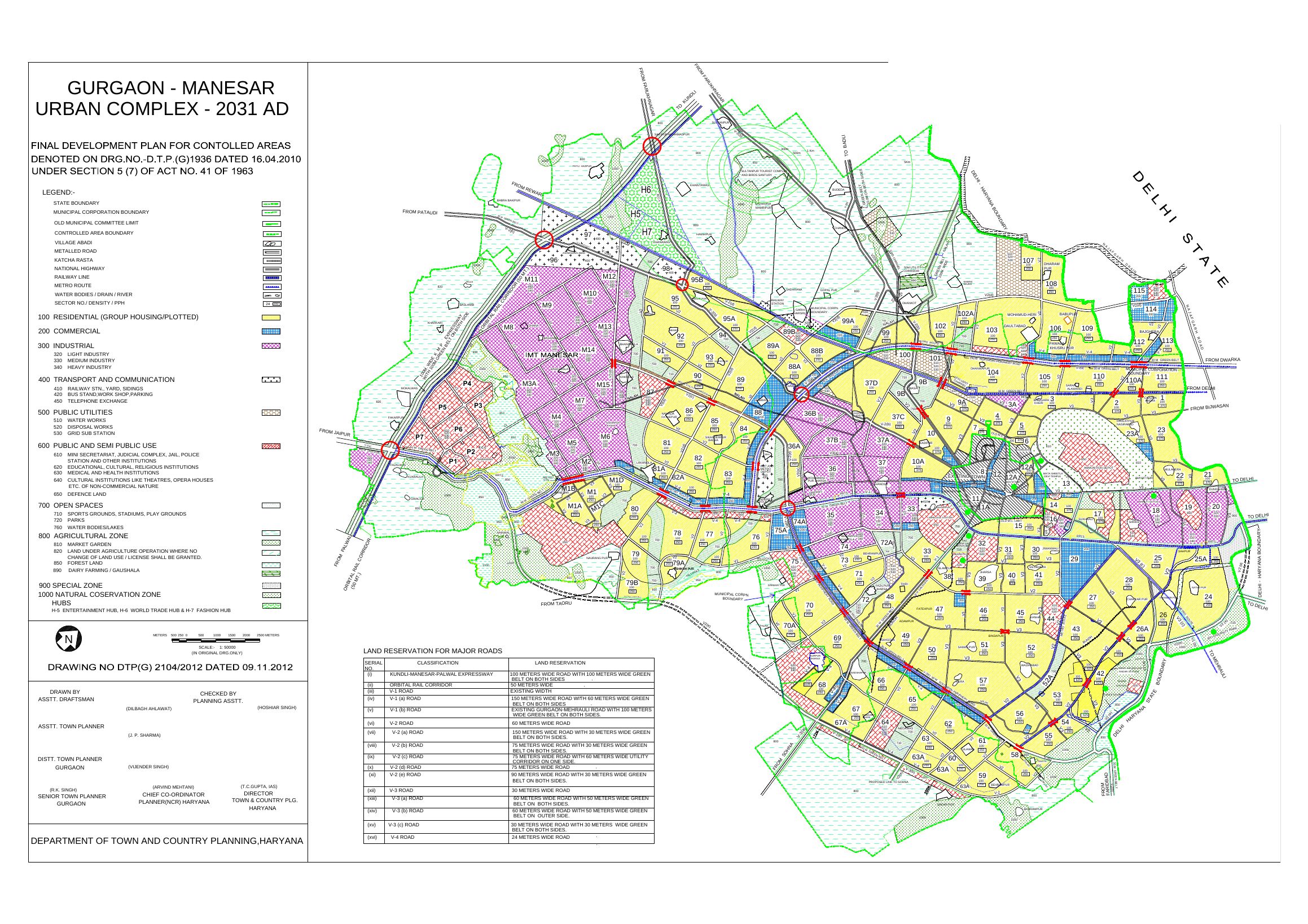
Where can I download the master plan PDF and map?
From DTCP's website, which lists the development plans of every town on its Development Plan page. For Gurugram there are three files: the notification with its text (25 pages), the plan drawing in black and white, and a coloured copy of the map. The coloured copy carries DTCP's own note that it is a digitised copy and that users should check it against the scanned copy of the notified plan. For anything legal, go by the notified plan.
How many people is it planned for?
42.50 lakh by 2031. The plan says the areas already developed, with the old town and the villages, would hold about 22 lakh people, and it added 22,957 hectares of new urban land for another 20.50 lakh. Its earlier version, the plan for 2021 notified in February 2007, was made for 37 lakh people.
What land is kept for what?
| Land use | Hectares |
|---|---|
| Residential | 16,021 |
| Commercial | 1,616 |
| Industrial | 4,613 |
| Transport and communication | 4,428 |
| Public utilities | 608 |
| Public and semi-public | 2,027 |
| Open spaces | 2,928 |
| Special zone | 114 |
| Defence land | 633 |
| Total planned land | 32,988 |
With the existing town (406 ha) and the village abadis (478 ha), the total is 33,872 hectares. A hectare is about 2.47 acres.
What does the plan say about homes?
Residential sectors are to be built as neighbourhoods, each with its own community facilities, at an average density of 250 persons per hectare. An amendment of 24 January 2017 lets each sector be built to the density shown for it on the drawing, 20% either way, plus the extra density that the licensing, affordable housing and transit oriented development policies allow. The plan also kept about 50 hectares in Sector 68 for smaller flats for low and middle income groups, at a higher density, and said the minimum road width in a residential colony is 12 metres.
Shops, offices and industry
New commercial land is meant for large malls and corporate complexes, with commercial belts 200 metres wide along selected roads, and about 48.5 hectares in Sector 99A for wholesale markets, to be built by the government. Industry gets 4,613 hectares, much of it along the expressway next to IMT Manesar. The 2017 amendment allows group housing and mixed use in parts of the commercial and industrial zones under the transit oriented development policy.
Roads and the metro, as the plan proposed them
The plan proposed new road links to Delhi: a 150-metre road from Dwarka to NH-8 before the toll plaza, and 90-metre links from Vasant Kunj to the Mehrauli road and from Andheria Mor to the Gurgaon-Faridabad road. In the new urban area, the roads between sectors are 75 or 60 metres wide. It reserves 100 metres for the Kundli-Manesar-Palwal Expressway, with green belts of 100 metres on each side, and 50 metres for the orbital rail corridor.
For the metro, it proposed extending the Delhi line from HUDA City Centre to Manesar through Sectors 43-44, 52-52A and 56-57, the Southern Peripheral Road and NH-8; extending the loop from Sikanderpur along Golf Course Road to the Southern Peripheral Road; a rapid transit corridor along the 150-metre road from Dwarka; and the regional rail line from Delhi to Alwar along NH-8. These are the plan's proposals of 2012, not a timetable; what is being built now is decided by the metro and rail agencies.
Green land, farmland and the Aravallis
About 135 hectares between Sector 24 and the Delhi border on the Mehrauli-Gurgaon road are a biodiversity park. A 900-metre strip around the ammunition depot must stay free of building, under the Works of Defence Act. Land outside the urban area is an agricultural zone, where only limited building is allowed, such as the growth of villages and farm houses under the plan's rules. The Aravalli hills are a Natural Conservation Zone, where farming, forestry and recreation are allowed with construction on no more than 0.5% of the land. Land notified under the Punjab Land Preservation Act and Aravalli plantation land is treated as forest, where no building is allowed.
What has changed since 2012?
24 January 2017: the amendment on sector density and on group housing and mixed use in the transit oriented development zone, described above.
13 June 2025, a draft: the government published a draft amendment that adds a "Global City Zone" of 411 hectares in Sectors 36, 36B, 37 and 37B, with a floor area ratio of 300, for industry, commerce, homes, institutions, recreation, transport, utilities and open space, to be developed only by the state's industrial corporation, HSIIDC. Industrial land would fall from 4,613 to 4,202 hectares. In Sector 36A, 229.81 acres would go to transport and communication and 231.18 acres to open space. Objections were invited for 30 days. On 20 November 2026 DTCP's Development Plan page listed no final notification of it, so it is still a draft.
December 2025: DTCP approved revised plans for six sectors near the Dwarka Expressway, among them 88A, 88B, 89A, 95A and 95B, realigning their main roads and the land for parks, schools and other services, The Tribune reported.
Is there a Gurgaon Master Plan 2041?
Not as a development plan. On 20 November 2026 DTCP's Development Plan page had no plan for Gurugram beyond 2031. Two other plans look to 2041. The Gurugram Metropolitan Development Authority approved a social infrastructure plan in 2023 that expects 55 lakh people by 2041 and lists the schools, hospitals and parks the city would need. And the NCR Planning Board's Draft Regional Plan 2041, for the whole of the capital region, backs five new townships along the KMP Expressway, The Tribune reported in June 2026. Neither is a development plan that sets the land use of a plot.
How do I check the land use of a plot?
Find the sector on the map and its colour in the legend: yellow for residential, blue for commercial, purple for industrial, and so on. The map is drawn at the scale of the city, so it cannot show the boundary of a single plot. The plan's zoning regulations say every change of land use and every development must follow the detailed sector plan. So for a plot you are buying, ask for its licence or change of land use (CLU) permission and check it with DTCP, and for a flat in a project, check its HRERA registration, which names the licence. A plot shown as agricultural zone cannot be built on as a colony without that permission.